Lemosho Route
BASE CAMP MOUNTAIN CLIMBING IN TANZANIA
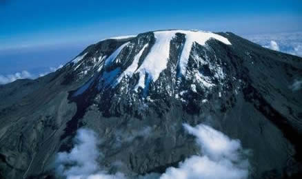
LEMOSHO ROUTE
This is an unspoilt, remote, less-used, and beautiful way up to the Shira Plateau. Trekkers sometimes use it to ascend the Western Breach route or follow it with the Kibo South Circuit to ascend by the easier Barafu Route. The first day of the route hardly ever has any game animals, and armed rangers never accompany a group.
The standard route takes 7 days on the mountain, and is sometimes extended to 8 days with a stay at Karanga Valley.
Route Outline
Drive from Moshi or Arusha to Londorossi Park Gate (2,250 metres (7,380 ft), 2 hours). From here a forest track requiring a four wheel drive vehicle leads to Lemosho Glades (2,100 metres (6,900 ft), 11 kilometres (6.8 mi), 45 minutes) and a possible campsite (park fees are not paid to camp here). Walk along forest trails to Mti Mkubwa (big tree) campsite, ((2,750 metres (9,020 ft), 3 hours).
The trail gradually steepens and enters the giant heather moorland zone. Several streams are crossed then it gains the Shira Ridge at about (3,600 metres (11,800 ft) and drops gently down to Shira 1 camp located by a stream on the Shira Plateau ((3,500 metres (11,500 ft), 7 hours). This campsite could be omitted.
A gentle walk across the plateau leads to Shira 2 camp on moorland meadows by a stream ((3,850 metres (12,630 ft), 4 hours). A variety of walks are available on the plateau making this an excellent acclimatization day.
Continue east towards Kibo passing the junction, then east towards the Lava Tower. Shortly after this, you descend to Barranco hut ((3,940 metres (12,930 ft), 6 hours).
A short scramble to the top of the Great Barranco and then a traverse over scree and ridges to the Karanga Valley ((4,000 metres (13,000 ft), 3 hours), beneath the icefalls of the Heim, Kersten, and Decken Glaciers.
After climbing out of the Karanga Valley, the trail ascends a ridge to the Barafu Hut, a bleak location with little vegetation at (4,600 metres (15,100 ft), (3 hours walking).
An early start for the ascent to the rim of the Kibo Crater between the Rebmann and Ratzel Glaciers, (6 hours). The last section before the rim can sometimes be snow-covered and an ice-axe or ski stick is useful for balance. At the rim, Stella point is reached (18,652 feet (5,685 m)). From here, a further hour leads to Uhuru Peak, from where there are often fine views of Meru to the west and the jagged peak of Mawenzi to the east. Descend to the Barafu Hut (3 hours) for a rest and lunch before continuing on past Millenium camp down to camp at Mweka Hut in the giant heather zone on the forest edge (4 hours). Those with energy on the summit may wish to descend to the Reutsh Crater and visit the ice pinnacles of the Eastern Icefields.
A 3-4 hour descent through forest brings you to the park gate.
